Section Menu
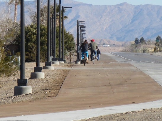
Bunkerville Bicycle and Pedestrian Trail
This 2.5 mile long path is a wonderful bicycle and pedestrian trail linking unincorporated Bunkerville and the City of Mesquite...
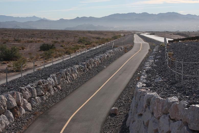
This 2.5 mile long path is a wonderful bicycle and pedestrian trail linking unincorporated Bunkerville and the City of Mesquite. The trail is separated but runs parallel to State Route 170 on the north side of the road, increasing bicycle and pedestrian safety along this stretch of highway. The trail is being enjoyed by the residents in both communities.
One of the most unique aspects of this trail is the lighting that was installed for increased safety at night. In the desert climate this is a great feature that lets trail users get some exercise after dark when the temperatures drop a little bit. Also there are benches and shade structures along the route to provide trail users a place to rest and get out of the sun. Additionally trail users will cross 3 bridges that span washes along the route keeping them safe from flood waters.
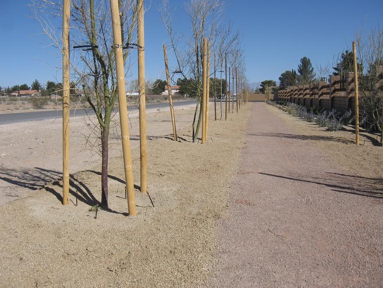
Duck Creek Trail
This multi-use trail runs approximately three-miles along the Duck Creek Wash between the Clark County Wetlands Park and Nellis Boulevard...
More Photos
Trails Map
Aerial Map
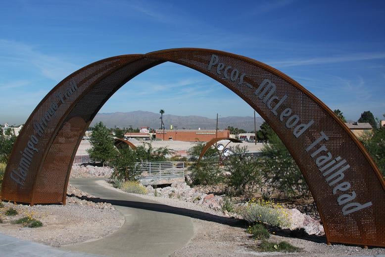
Flamingo/Arroyo Trail, Boulder Highway to Pecos/McLeod
This section of the multi-use pedestrian trail stretches a little over a mile along the Flamingo Wash and serves as an extension of the Flamingo Arroyo Trail...
Learn More
This section of the multi-use pedestrian trail stretches a little over a mile along the Flamingo Wash and serves as an extension of the Flamingo Arroyo Trail.
This segment is an important middle-link to the eastern portion of the Flamingo Arroyo Trail. The eastern terminus connects to the Clark County Wetlands Park and also provides connections to Federal Lands on the east side of the valley.
More Photos
Trails Map
Aerial Map
Flamingo/Arroyo Trail, Phase I
This eastern most segment of the Trail has been open since 2008 and was the first stretch of the Flamingo Arroyo Trail...
Learn More
This eastern most segment of the Trail has been open since 2008 and was the first stretch of the Flamingo Arroyo Trail. The trail spans 2.5 miles between Vegas Valley and the Sunrise Trailhead that is located on the northern boundary of the County Wetlands Park. To get to the trailhead go east on Vegas Valley Drive then turn south on Hollywood and follow the road for about 2.5 miles.
For a few years, the Sunrise Trailhead was the eastern most destination of the Flamingo Arroyo Trail. A new trail connection now takes trail users to the County Wetlands Park where they can continue east through the Park along the north side of the Las Vegas Wash. This is a very scenic trail section with great views of nature in and around the Wash. This is also an important trail segment because users can now connect with trails in Henderson and to the River Mountains Loop Trail as well.
More Photos
Trails Map
Aerial Map
Flamingo/Arroyo Trail, Phase II
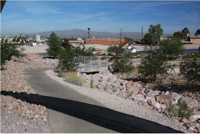
Completed in the fall of 2010, this phase of the project included the installation of unique public amenities along portions of the Flamingo/Arroyo Trail...
Learn More
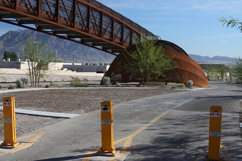
Completed in the fall of 2010, this phase of the project included the installation of unique public amenities along portions of the Flamingo/Arroyo Trail. These amenities include trailheads, benches, signs, entry archways and shade shelters. Trailheads are located near Pecos McLeod, Lamb Boulevard, Sloan Lane and a wayside west of Sunrise Trailhead.
It is interesting to note that the artists hired to design many of the amenities, Kevin Berry, Barbara Grygutis and Buster Simpson, took much of their inspiration for the shade shelters/benches from early Paiute basketry and shade shelters.
To add some local historic flavor, the artists also incorporated large pieces of concrete rubble from the Stardust Hotel that was built in 1955 and imploded in 2007. These blocks from the Stardust pool were installed at the Pecos McLeod and Lamb Boulevard trailheads to serve as benches.
More Photos
Trails Map
Aerial Map
Flamingo/Arroyo Trail, Stephanie Street to I-515
This three-mile section of the Flamingo Arroyo Trail serves as part of the Las Vegas Valley Primary Trails System. Some parts of this trail are even lighted for use at night...
Learn More
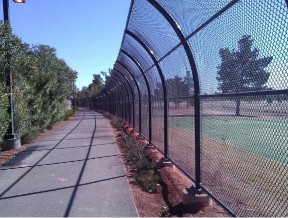
This three-mile section of the Flamingo Arroyo Trail serves as part of the Las Vegas Valley Primary Trails System. Some parts of this trail are even lighted for use at night.
This unique trail combines on-street connections on Nellis and Sahara and off-street segments adjacent to the Flamingo Wash between Nellis and I-515. The eastern end of the trail connects to a pedestrian bridge over Vegas Valley allowing users to continue on to the Sunrise Trailhead to the south. It also connects to the Las Vegas Wash Trail near Sloan Lane.
Cyclists traveling west to east need to take note that they will be transitioning from the trail to the street after crossing the pedestrian bridge at Nellis. They will then ride north on Nellis and east on Sahara to connect with the Las Vegas Wash Trail at Sahara and Sloan Lane. The reverse route also utilizes Sahara and Nellis to reconnect with the Flamingo Arroyo Trail west of Nellis. Pedestrians can use existing sidewalks to make this connection in either direction.
More Photos
Trails Map
Aerial Map
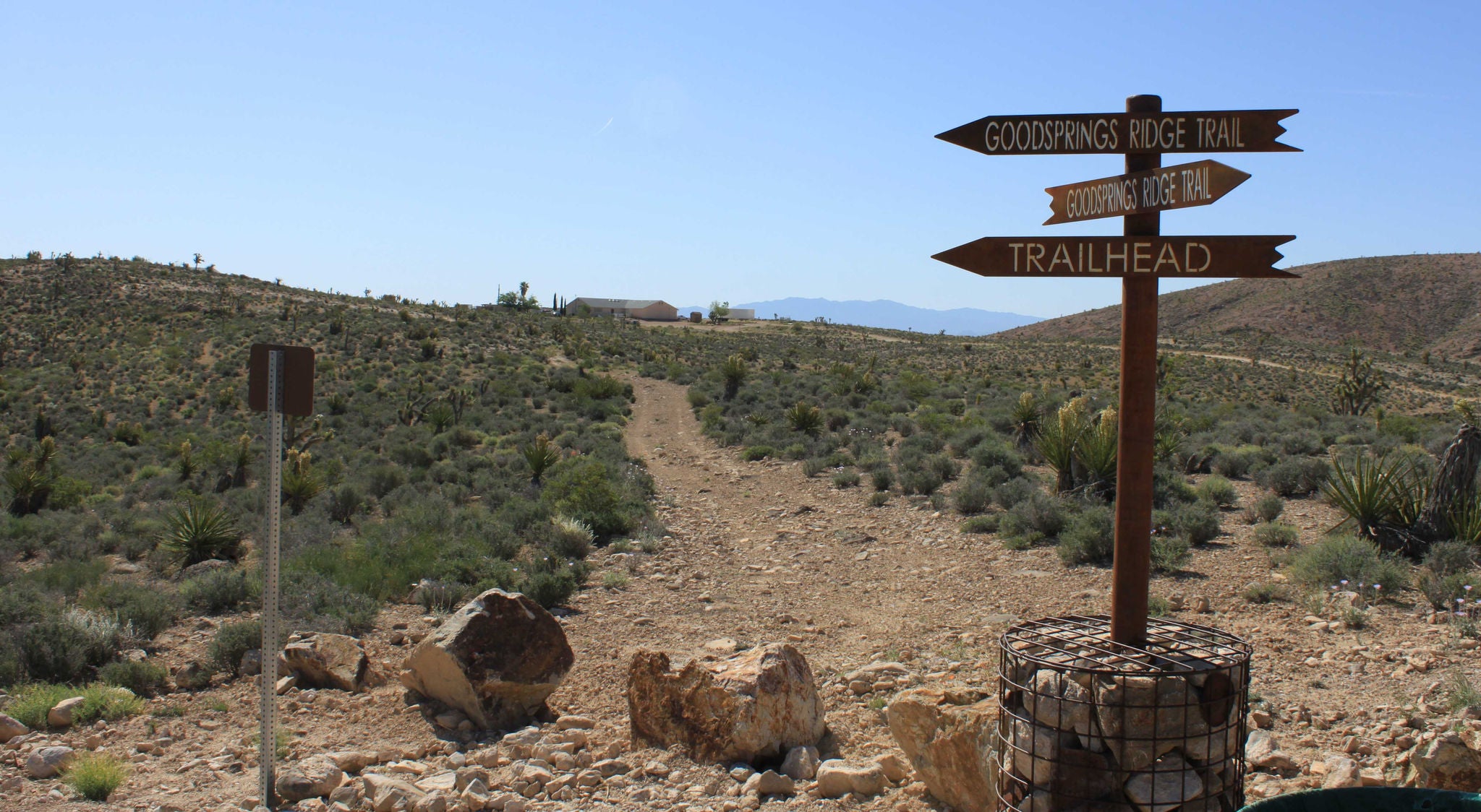
Goodsprings Trail
The 2.3 mile loop gravel Goodsprings Trail was constructed in 2019. The trail was funded by the Southern Nevada Public Land Management Act (SNPLMA) and includes amenities such as a parking lot and restrooms. Buildings ...
Learn More
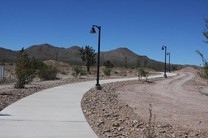
The 2.3 mile loop gravel Goodsprings Trail was constructed in 2019. The trail was funded by the Southern Nevada Public Land Management Act (SNPLMA) and includes amenities such as a parking lot and restrooms. Buildings are designed to resemble those of ghost towns or mining claims.
Along the trail users will see into the past of Goodsprings though interpretive signage with such themes as mining, geology and the Old Spanish Trail route.
A section of the trail known as Yellow Mine Railroad Trail reflects the Goodsprings history of lead and zinc mining. A bridge constructed to resemble a metal railroad car is a highlight of the trail. The trail is located adjacent to the Goodsprings Fire Station and can be accessed via Beacon Street.
Trails Map
Aerial Map
I-215 East Beltway Trail, Warm Springs to Pecos
Extending for almost 4 miles along the west side of the I-215 Beltway, between Warm Springs and Pecos, this popular trail is an important component of the Las Vegas Valley Primary Trail System...
Learn More
Extending for almost 4 miles along the west side of the I-215 Beltway, between Warm Springs and Pecos, this popular trail is an important component of the Las Vegas Valley Primary Trail System. It serves as a continuation of the trail along I-215 in the City of Henderson. This trail provides recreation opportunities and an alternative transportation route for some employees that bike to work.
More Photos
Trails Map
Aerial Map
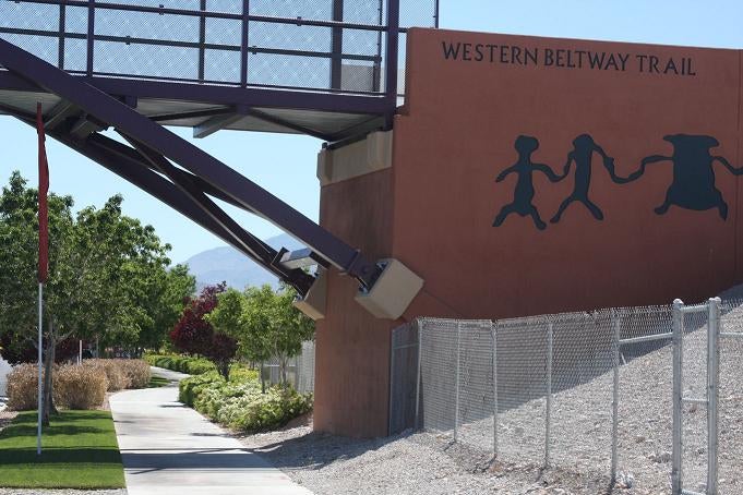
I-215 West Beltway Trail, Tropicana to Charleston Boulevard
The trail extends just over 5 miles along the western side of the I-215 Beltway between Tropicana and Charleston...
Learn More
The trail extends just over 5 miles along the western side of the I-215 Beltway between Tropicana and Charleston. This trail segment is an important component of the Las Vegas Valley Primary Trails system and a key link to trails in the City of Las Vegas.
This unique trail provides not only recreation opportunities but it serves a dual role as an alternative transportation route for employees that bike to work in this part of the Valley. Surveys indicate that this is a popular trail for bikers and with the completion of this one-mile extension use is certainly expected to increase.
More Photos
Trails Map
Aerial Map
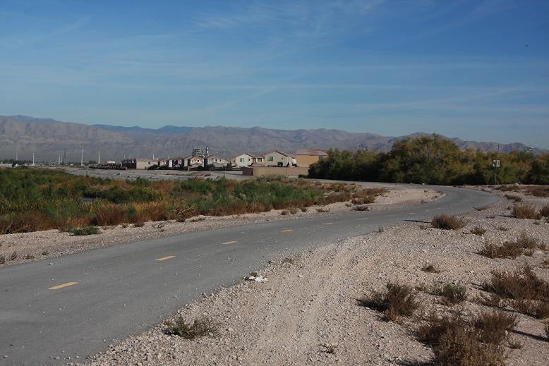
Las Vegas Wash Trail, Christy Lane to Charleston Boulevard
The trail from Christy Lane to Charleston Boulevard begins just south of Starridge Way and meanders along the eastern perimeter of the Desert Rose Golf Course...
Learn More
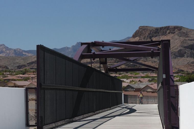
The trail from Christy Lane to Charleston Boulevard begins just south of Starridge Way and meanders along the eastern perimeter of the Desert Rose Golf Course. The trail then crosses Nellis Boulevard on a new pedestrian bridge and continues north to Charleston Boulevard. This trail segment is slightly less than a mile in length but it will connect to future regional trail projects in Las Vegas and North Las Vegas. The trail also serves as an important link to the Clark County Wetlands Park and federal lands to the south.
More Photos
Trails Map
Aerial Map
Las Vegas Wash Trail, Karen Avenue to Christy Lane
This on-street portion of the Las Vegas Wash trail runs about 1.2 miles along Sloan Lane and on to Ballinger...
Learn More
This on-street portion of the Las Vegas Wash trail runs about 1.2 miles along Sloan Lane and on to Ballinger. It provides a connection from the Flamingo-Arroyo trail to the trail that runs from Christy Lane to Charleston near the northern end of the Desert Rose Golf Course. This trail segment is a mid-point link to the future regional trail projects in Las Vegas and North Las Vegas along the Las Vegas Wash. The trail also serves as an important link to the Clark County Wetlands Park and federal lands to the south.
More Photos
Trails Map
Aerial Map
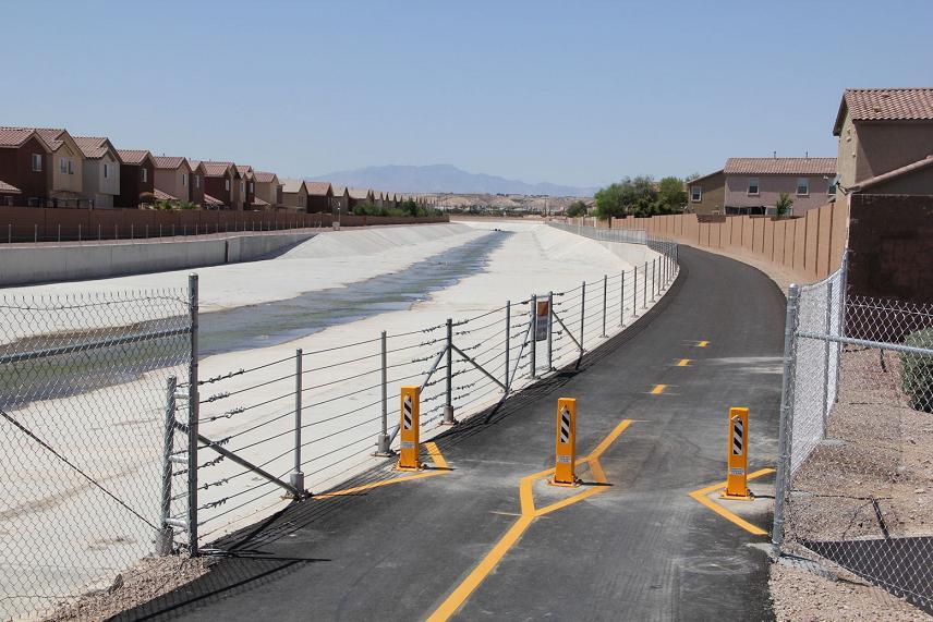
Las Vegas Wash Trail, Owens Avenue to Lake Mead Drive
This one-mile County segment of the Las Vegas Wash trail is a key component of the Las Vegas Valley primary trails system...
Learn More
This one-mile County segment of the Las Vegas Wash trail is a key component of the Las Vegas Valley primary trails system. This multi-use pedestrian trail along the Las Vegas Wash was completed in late 2012. This trail segment provides a critical link to the trail systems in the Cities of Las Vegas and North Las Vegas.
Trails Map
Aerial Map
Laughlin Regional Trail/North Reach Recreation Area
Laughlin's Colorado River Heritage Greenway Park and Trails project, was named one of the nation's most promising projects designed to protect special places and reconnect Americans to the outdoors...
Learn More
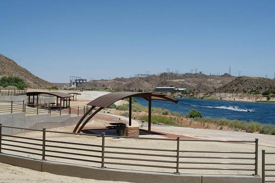
Laughlin's Colorado River Heritage Greenway Park and Trails project, was named one of the nation's most promising projects designed to protect special places and reconnect Americans to the outdoors.
The project, also known as the North Reach, officially opened to visitors in 2012. The Colorado River Heritage Greenway Park and Trail project is an amazing amenity for the community of Laughlin. It will greatly enhance the area as a destination for eco-tourism and outdoor adventure, and it will help preserve unique vistas and landscape for future generations.
The project consists of 9 miles of trails in the Laughlin area for bicyclists, pedestrians and equestrian riders, and includes expansion of the Laughlin Riverwalk, fully developed restrooms and trailheads, picnic sites, shade shelters, fishing piers, and a highway pedestrian bridge overpass and underpass providing access to the Colorado River. Visitors of all abilities can enjoy the trails and accessible fishing areas.
The Colorado River Heritage project is part of a larger regional trails system designed to link Laughlin and the surrounding community to the Lake Mead National Recreation Area and parts of Arizona.
The project has been nationally recognized as both an America's Great Outdoors Initiative Project and an America's Great Outdoors Rivers Initiative Project. The America's Great Outdoors Initiative highlights two projects in each of the 50 states that promote conservation and outdoor recreation and the America's Great Outdoors Rivers Initiative identifies 10 projects in the Pacific Northwest and Western States.
More Photos One; More Photos Two
Trails Map; Completed Project Map
Aerial Map
Moapa Valley Trail, Phase I
The Moapa Valley Phase I Trail was constructed in the old Logandale area of northern Moapa Valley...
Learn More
The Moapa Valley Phase I Trail was constructed in the old Logandale area of northern Moapa Valley. Specifically, the trails connect Bowler Elementary School to Moapa Valley High School and the Clark County Fairgrounds. The trail includes about four-miles of multi-use pedestrian trail and an east/west OHV connector trail along Whipple Avenue.
Trails Map
Aerial Map
Searchlight Center Park Trail
The Searchlight Center Park Trail project enhances the recreational opportunities in this rural community...
Learn More
The Searchlight Center Park Trail project enhances the recreational opportunities in this rural community. This first phase included the construction of approximately one mile of multiple use non-equestrian/non-motorized trail on the property adjacent to the existing Searchlight Community Center.
More Photos
Trails Map
Aerial Map
Sunrise Trailhead
The Sunrise Trailhead serves as a vital staging area for equestrians and non-motorized trail users near the Clark County Wetlands Park and the Sunrise Management Area...
Learn More
The Sunrise Trailhead serves as a vital staging area for equestrians and non-motorized trail users near the Clark County Wetlands Park and the Sunrise Management Area. This trailhead also provides linkages to the River Mountains Loop Trail, Rainbow Gardens Trails and the Flamingo/Arroyo Trail.
To get to the trailhead go east on Vegas Valley Drive then turn south on Hollywood and follow the road for about 2.5 miles.
More Photos
Tropicana/Flamingo Washes Trail
This expansive trail project functions as a regional backbone consisting of off-street trails and on-street connections in the southwestern part of the Las Vegas Valley...
Learn More
This expansive trail project functions as a regional backbone consisting of off-street trails and on-street connections in the southwestern part of the Las Vegas Valley. The network ultimately spans roughly 23 total miles between Charleston and Wigwam, and Decatur and the Red Rock detention basin, offering a unique variety of trail experiences.
Families, walkers, runners, cyclists and even equestrians can enjoy different trails in this part of the Valley. The combination of trails and on-street connections link up with parks, schools, neighborhoods, commercial developments and even an equestrian trailhead on Wigwam and Durango.
More Photos
Trails Map
Aerial Map
Western Trails Park Area Equestrian Trails
More than 4 miles of marked equestrian trail alignments meander along rural roads to the south and east of Clark County’s Western Trails Park...
Learn More
More than 4 miles of marked equestrian trail alignments meander along rural roads to the south and east of Clark County’s Western Trails Park. The Park is located south of Warm Springs at Rogers. The trails serve to compliment the equestrian park by connecting local equestrians in this neighborhood to the existing park facilities.
More Photos
Trails/Aerial Map